John Ross Ferrara / Thursday, Feb. 10, 2022 @ 5 p.m. / Ocean
(VIDEO) Simulation Shows How Tonga Tsunami Spread Across the Pacific
A simulation of wave propagation in the Pacific caused by the Tonga eruption. | NOAA
The National Oceanic and Atmospheric Administration has released a simulation of last month’s tsunami that triggered warnings in Humboldt County and around the Pacific.
The “tsunami propagation” animation, put together by the Tsunami Research NOAA Pacific Marine Environmental Laboratory, shows tsunami waves and ocean disruption produced by the massive volcanic eruption on the uninhabited South Pacific island of Hunga Tonga-Hunga Ha‘apai on January 15.
Jonathan Garner, senior meteorologist with Eureka’s National Weather Service office, told the Outpost that NOAA created the animation using the Method of Splitting Tsunami numerical simulation model — used by researchers to effectively study tsunami behavior and make long-term predictions.
“This is the tsunami movement away from the [volcano] on Jan. 15,” Garner said of the simulation.

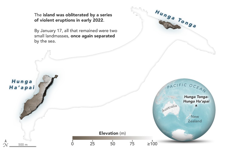
Hunga Tonga-Hunga Ha‘apai was blown apart by the powerful eruption. | NASA
While NASA’s Earth Observatory reported that the eruption was hundreds of times more powerful than the Hiroshima bomb, few deaths have been reported as a result of the blast and ensuing tsunami.

The eruption seen from space. | NASA
“This is a preliminary estimate, but we think the amount of energy released by the eruption was equivalent to somewhere between 4 to 18 megatons of TNT,” said Jim Garvin, Chief Scientist of NASA’s Goddard Space Flight Center. “

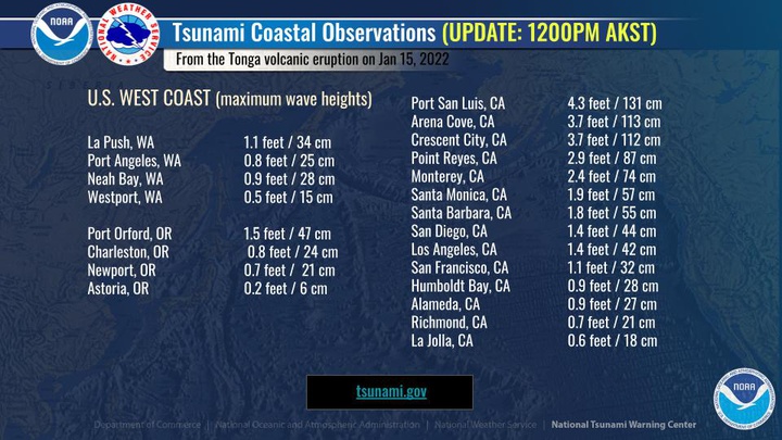
Maximum wave heights seen across the western United States on Jan. 15. | NOAA
The Jan. 15 blast produced tsunami waves less than a foot high in Humboldt County. Crescent City, meanwhile, saw tsunami waves as high as 3.7 feet — the second largest tsunami waves measured in the contiguous U.S. that day.

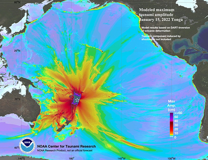
The elevation or "maximum amplitude" a floating object would have experienced due to the Jan. 15 tsunami. | Graphic by NOAA
CLICK TO MANAGE