Jessica Cejnar Andrews / Friday, May 10, 2024 @ 11:10 a.m. / Community, Ocean, Wildlife
Coastal Commissioners View Pebble Beach Drive, Pt. St. George, Pacific Shores During First Visit to Crescent City Since 2014
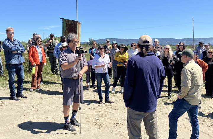
Coastal commissioners visited Lake Earl to learn about the Pacific Shores Subdivision. | Jessica C. Andrews
Suntayea Steinruck used song to welcome California Coastal Commissioners to the land her people have occupied since time immemorial.
An integral step in breaking down barriers and working with others, Steinruck, a former tribal historic preservation officer for the Tolowa Dee-ni’ Nation, said one song was about “the place that falls into the ocean.”
“This is such a magnificent place for us,” she told commissioners from atop the bluff at Point St. George. “We have a connection here. We will always have a connection here.”
Connectivity was a theme for commissioners on Thursday. On the second of a three-day meeting — the first held in Del Norte County since about 2014 — they took a field trip to view the landslide impeding traffic on Pebble Beach Drive. Commissioners then visited Point St. George to hear about efforts to complete the California Coastal Trail before visiting the former Pacific Shores subdivision.
The issues weren’t before commissioners for an official vote this month, but Melissa Kraemer, the Coastal Commission’s North District manager said the field trip gives them a sense of place when these projects do come before them.
One commissioner, Imperial Beach Mayor Paloma Aguirre, who represents the San Diego Coast, said this week’s visit was her first time in Del Norte County.
“There’s great work being done, but it’s challenging. It involves many stakeholders” she told the Wild Rivers Outpost alongside Lake Earl, mentioning the California Coastal Trail in particular. “It’s admirable [that] it’s at the last mile and a half. It’s a picture of success.”
Pebble Beach Drive
Nearly four months after a January storm ate into the bluff alongside Pebble Beach Drive, Crescent City Mayor Blake Inscore pointed at Candace Tinkler’s house to emphasize the need for a permanent fix.
The first stop on their field trip, Coastal Commissioners learned about the dilemma facing Crescent City as they seek emergency dollars to reopen the road and funding for the larger $32 million Pebble Beach Drive Bank Stabilization Project. The latter will fix storm damage from 2016 and stretches from 6th Street to Preston Island.
“Seeing it is always good,” Inscore told the Wild Rivers Outpost. “They were looking right at it. They understand the proximity to homes and the connectivity, that it’s a primary feeder street.”
On Wednesday, Public Works Director David Yeager gave a description of the erosion along Pebble Beach Drive via Power Point. The erosion rate ranges from 0.2 to 1 foot per year, he said. By 2075, about 1,200 feet of roadway is anticipated to be gone.
On Thursday, Yeager told commissioners that the design for the larger project is about 30 percent completed.
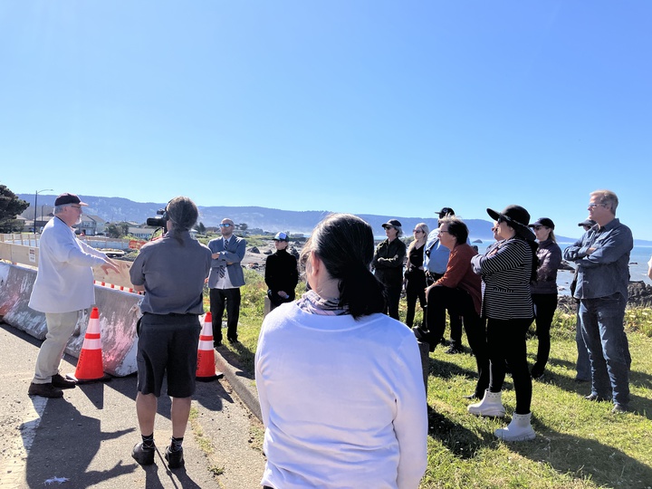
Public Works Director David Yeager tells Coastal Commissioners about the funding dilemma Crescent City faces in reopening Pebble Beach Drive. | Jessica C. Andrews
A pocket beach to the north of Brother Jonathan Lookout gets more wave action than the area that slid, which is to the south, Yeager said.
After this description, Coastal Commission Vice Chair Linda Escalante asked if the city thought about redesigning Pebble Beach so it’s safer for pedestrians.
“Maybe this requires less armoring so it’s more mobility-friendly, but not for cars,” she said, adding that she and her colleagues learned that Pebble Beach can get congested during the summer. “[Maybe] push the cars to the next row.”
Tinkler, who is on the city’s Measure S Oversight Committee, said she was glad commissioners could view Pebble Beach at low tide.
She noted the area is so rocky that it’s almost impossible to walk on it. The road closure has also had a negative impact on nearby streets such as 8th Street, she said.
“Eighth Street used to be quite quiet,” she said. “It was very favored by walkers and dog walkers. We have a playground. Now we’ve got really fast traffic. There’s three times the traffic.”
According to Kraemer, there are two coastal development permit applications related to Pebble Beach pending, one belonging to Crescent City and the other belonging to Del Norte County.
Coastal Commission staff has asked for supplemental information before they could move forward on processing those applications, she told the Wild Rivers Outpost.
“In the meantime, we’re meeting, especially with the city, which is working on plans for emergency stabilization,” she said.
California Coastal Trail Connectivity
Coastal Commission Legislative Director Sarah Christie highlighted the significance of a project to extend the California Coastal Trail by drawing commissioners’ attention to the end of the bike path at Pebble Beach Drive and Washington Boulevard.
A left turn will take you to the Del Norte County Regional Airport, but there’s no pedestrian access to Point St. George, she said. A collaborative project between the state, county, Tolowa Dee-ni’ Nation and the Smith River Alliance seeks to change that, Christie said.
“On the other side of the gate there’s a broad sandy beach,” Christie told commissioners. “You could walk to Pacific Shores, walk to the mouth of the Smith River, go up a stairway and go down a stairway and walk to the Oregon border.”
Using about $1.5 million in California Coastal Conservancy dollars, the Smith River Alliance is partnering with California State Parks, the Department of Fish and Wildlife and Del Norte County to add 1.25 miles to the coastal trail.
In addition to making the parking lot at Point St. George ADA compliant, the project includes adding 800 feet of boardwalk, taking visitors above a wetland as well as installing multiple retaining walls and a bridge, said Melody Vaughn, a “trail boss” with California State Parks.
Once the project is complete, only two to three gaps remain before the California Coastal Trail traverses the entire county, said Coastal Conservancy Project Manager Peter Jarausch said.
The Point St. George area houses two federally listed plant species and a federally listed butterfly.
The California Coastal Commission is holding pre-application meetings with Point St. George stakeholders, Kraemer told the Outpost.
Pacific Shores
On Wednesday, Josefina Barrantes, Del Norte advocate for the Environmental Protection Information Center, raised concerns about off-highway vehicle use near Lake Earl during western snowy plover nesting season.
During a visit to Pacific Shores last July, Barrantes said, she saw bikes “ripping through the sand dunes.” No signs were posted indicating that off-highway vehicles were prohibited and that threatened species were nesting in the sand at that time, she said.
“When leaving Pacific Shores, I saw more people happily unloading ATVs from a truck, getting ready for a day of ripping through habitat,” she told commissioners. “I like to believe in the best in people and that if people were to see signs on the beach in Del Norte County saying they cannot drive through the dunes or on the beach that some people would listen. If not, I am certain that permanent fencing and boulders would also discourage such harmful recreation.”
Though she wasn’t able to see the damage from her vantage point with her colleagues at the end of Tell Boulevard, Coastal Commission Chair Dr. Caryl Hart asked CDFW representative Shawn Fresz about off-highway vehicle use and whether it’s even legal.
Fresz, CDFW’s Northern Region Lands and Wildlife Program supervisor, said enforcing regulations is difficult because the state doesn’t have full ownership of Pacific Shores. About 80 percent of the land at Pacific Shores is part of the Lake Earl Wildlife Area, he said.
CDFW has been working with the Smith River Alliance, California State Parks and Del Norte County consolidating the former subdivision into the wildlife area, he said.
The Pacific Shores Acquisition Program is another project that’s part of a partnership between California State Parks, CDFW, Del Norte County and Smith River Alliance. Smith River Alliance’s co-director, Patty McCleary, said she’s been working since about 2002 on purchasing private land in the subdivision.
Out of an original 1,535 lots created when the area was subdivided back in the 1960s and sold to unwitting buyers in Los Angeles and elsewhere, McCleary said the nonprofit has about 300 parcels left to purchase.
In February, the California Coastal Conservancy received authorization to disburse up to $1.3 million to the Smith River Alliance for the Pacific Shores Acquisition Program. About $500,000 of those dollars was for pre-acquisition planning activities and minor cleanup. The rest, about $800,000, was to continue acquiring parcels.
According to Fresz, his department aims to provide safer access to the lagoon for the public and keep non-native species at a minimum.
“This type of complexity is not normal for our department,” he told commissioners, referring to the number of partners involved in the project. “The ultimate outcome is to have this [be] a gem of public access that all of our community can use.”
The land management plan is currently under review at CDFW’s headquarters in Sacramento, Fresz said. He said his goal is for the plan to be reviewed by other agencies, including the Coastal Commission, later this year.
During the Commission’s visit, Humboldt County Supervisor Mike Wilson, who was appointed to the commission by the governor, asked if there was anything he and his colleagues could do to move the project forward.
McCleary credited Del Norte County staff for the work they do addressing nuisance properties. She said she also keeps a list of property owners who don’t want to sell.
“With 300 individual parcel owners remaining, we’re going to work real hard over the next couple of years,” McCleary said. “I think we will know [who] the holdouts are going to be in a couple of years.”
CLICK TO MANAGE