Jessica Cejnar Andrews / Wednesday, Feb. 9, 2022 @ 3:20 p.m. / Weather
Crescent City Experiences Potentially Record-Breaking Warmth, 8.7-Inch Water Deficit Since October
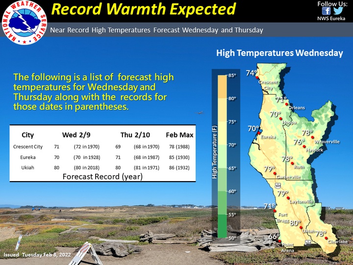
Courtesy of www.weather.gov/eka
An area of high pressure parked over the Pacific Ocean and a thermal trough bringing inland heat to the coast is responsible for the potentially record-breaking temperatures Crescent City saw on Wednesday.
That heat played tug of war with the cool maritime air Crescent City residents are more accustomed to this time of year, causing temperatures to fluctuate between 50 degrees and 70 degrees, National Weather Service meteorologist Josh Wood told the Wild Rivers Outpost.
“We’re tying and breaking records today,” Wood told the Outpost, though he said the high temperatures for the day hadn’t officially been set yet. “The record temperature for Crescent City today was 72 degrees (set on Feb. 9, 1970). We may have at least met that and tied the record.”
NWS forecasters predicted near-record high warmth throughout the North Coast on Wednesday with Eureka potentially seeing 70 degrees and Ukiah possibly hitting 80.
Those high temperatures are expected to last through Thursday with Crescent City potentially seeing 69 degrees, breaking a record set on Feb. 10, 1970, according to the NWS.
Warm temperatures will linger offshore on Friday, but that thermal trough should be weakening, Wood told the Outpost.
That area of high pressure over the ocean is also responsible for the precipitation deficit Del Norte County and other areas in Northern California and Southern Oregon has been experiencing, Wood said.
Crescent City is 8.7 inches below what would be considered normal rainfall from October to date, Wood said. Normal is 34.4 inches of precipitation for this time of year. Crescent City has had 25.7 inches, he said.
Crescent City has received 2.94 inches of rain since Jan. 1, 2022, Wood said. Normal for the calendar year would be 11.37 inches, he said.
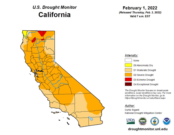
Courtesy of the U.S. Drought Monitor
There may be a chance for light rain next week, but Wood said it would be a very small amount.
“It’s just been a really dominant and unseasonably anomalous Pacific high pressure ridge that’s blocked everything,” he told the Outpost. “It’s been parked out there and it acts as a block for any system coming in.”
According to the U.S. Drought Monitor, Del Norte County is currently considered abnormally dry. The rest of California, including Siskiyou, Humboldt, Trinity and Modoc counties are experiencing moderate to extreme drought conditions.
Wednesday’s warm temperatures even led to fire weather concerns for Lake County because of the lack of rain, Wood said.
“It will be very tough to make up the deficit from what we lost in January,” he said.
CLICK TO MANAGE